
This post takes a closer look at the unmonitored stream segments in Jamestown – segments of Deep River, Bull Run, Copper Branch, etc. that we have asked the NCDEQ and EPA to add to the 2024 IMPAIRED WATERWAYS 303(d) LIST (with no response).
1.DEEP RIVER, Assessment Unit NC17-(3.3). This segment of Upper Deep River runs through the heart of Jamestown. This is a Class IV Water Supply Stream, it tested positive for eight PFAS, it’s overgrown and unkept, and it’s not on the EPA’s ‘Hows my Waterway’ map. This segment receives groundwater from an “underground plume” on Main Street and several industrial and NC “inactive hazardous sites” (UNIVAR Chemical Corp., MONARCH/CHROMECRAFT FURNITURE, STAPLES METAL FASTENERS).
This segment of Deep River comes out of High Point City Lake, winds through town, past Wade Street, Scientific Street, goes under Dillon Road at the train tracks (a block south of Main Street) and ends at Teknor Apex, as shown here:

Here’s a September 2024 PFAS test summary for the untreated wastewater that comes out of Teknor Apex:

On March 31, 1999, the NCDEQ classified this stream as a WS-IV* Critical Water Supply stream, bit it does not appear on the EPA’s interactive U.S. Waterways database map. (It is the NCDEQ’s job to report stream classifications and water assessment data to the EPA.)
This is shown below – when you click on this segment of Deep River on the EPA’s map, no info is returned:

This past November Stephanie Stephens, a local student, kayaked Deep River and took photos and samples.
When she wrote “Water quality is poorest along the Guilford County section of the Deep River as far as I can see from the kayaking I have done,” she was talking about this segment of Deep River in Jamestown. She posted “The water is nearly black through here and gunky, entirely still, with little to no maintenance along the river to keep pollution, fallen trees or sediment buildup from negatively impacting the river. There was a foul smell for most of the trip this afternoon. I saw no signs of aquatic life.”
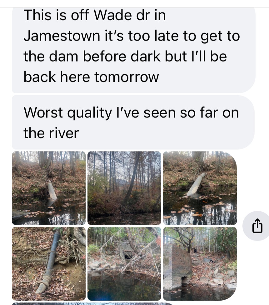


More pipes and an unidentified brick structure:


Note the large open pipes coming out of the bank (below left) and the black water. Again, this is all in the segment of Deep River known as NC17-(3.3).


301 N. SCIENTIFIC (contaminated) – Across Deep River from Wade Street is a Superfund site that’s ranked number 82 on North Carolina’s list of inactive hazardous sites. The contamination (Cadmium, Chromium, Cyanide, Lead, Nickel, Mercury, Selenium, Copper, Zinc) is from former owners Monarch Furniture and Chromecraft Furniture. It has remained on the list because the next owner – Greensboro Metal Parts – said it wasn’t his problem since he didn’t make the mess.
3516 DILLON ROAD, STAPLES LLC (contaminated) – The rundown brick building where Dillon Road crosses the railroad tracks is also a contaminated Superfund site. Former owner is a metal fasteners manufacturer called L.P. Staples/Powerline Fasteners. A memo to the file states that this former manufacturing facility had a toxic waste lagoon.


Groundwater sampling at Staples in June, 1993, found 23,000 ppb of Acetone and 6 ppb of perchloroethylene. VOCs and petroleum hydrocarbons were also found in the groundwater. In April 1993, Pyrene, chrysene and benzo-anthracene were found in soil samples. In July 1993, 560 ppm of petroleum hydrocarbons were found in soil samples. On site excavation revealed leaking pipes and other problems. In July and August 1994, monitoring wells found high levels of acetone, tetrachloroethane, and bis (ethylhexy) phthalate. Present condition is unknown but nothing appears to be going on at the site.
Some of Staples’ historical files are below:
MORE historical files for Staples are below:
Teknor Apex, 3518 Dillon Road (discharging) – This company is somehow allowed to discharge into Deep River under a General NPDES permit from the Division of Water Resources for FINISHED APPAREL, PRINTING, LEATHER, RUBBER & MISC. MANUFACTURING (see the permit category HERE).

Teknor Apex is a manufacturer of PVC Building Materials (PVCs are a source of PFAS) and the company’s owner calls Jamestown its “vinyl division:”

The NC Division of Air Quality issued an air emissions permit to Teknor Apex under SIC Code 3087 for CUSTOM COMPOUNDER OF PURCHASED PLASTICS RESINS (permit no. 10379R01). BUT – the NC Division of Water Resources has, for years, granted Teknor Apex/Viking Polymers a General NPDES permit for FINISHED APPAREL, PRINTING, LEATHER, RUBBER & MISC. MANUFACTURING (see the permit category HERE).


UNIVAR Chemical Company (discharging, underground tanks) – Located at the corner of Oakdale and Main Street, groundwater flows to a tributary to Deep River, along with groundwater from contaminated 102 and 109 Main Street properties across the street. Extensive documentation about leaking underground tanks exists in the NCDEQ public records archives; Univar holds a General NPDES permit; the files are in this DROPBOX. More on UNIVAR is HERE.
In December 2024, the Univar properties on Oakdale were purchased by Fortress Investment Group, a subsidiary of Abu Dhabi (United Arab Emirates) sovereign wealth fund Mubadala Investment Company. Mubadala is a longtime investment PARTNER of Apollo Global Management Inc., which acquired UNIVAR Solutions in 2023 for $8.1 billion.
Attached to the sales agreement was a 20-page REMEDIATION AND ACCESS AGREEMENT for the purpose of “allocating liabilities, responsibilities, expenses and other matters relating to the presence of Hazardous Substances that may be present at, on, or beneath the Property.” The sale and remediation agreement links are HERE.


102 West Main Street (contaminated) – a former drycleaner, this one has sat vacant for years due to contamination issues. TCE vaporization is taking place, and a plume of contaminated groundwater flows southwest to a tributary to Deep River and the shopping center.
HOOD Container (former Highland Container) (discharging) – corrugated cardboard manufacturer, holds the same General NPDES permit as Teknor Apex – for Finished Apparel (cutting & sewing), Printing, Leather & Rubber. The Air Emissions Permit (05793/R08) is for “CORRUGATED & SOLID FIBER BOX MANUFACTURING.” Hood was allowed to forgo air permitting last May because the company told the state it doesn’t emit as much sulfur dioxide, nitrogen oxide, carbon monoxide and toxic air pollutants as they used to. This video was shot yesterday, May 13, 2024 at 6:28 p.m. It’s always smoking. [UPDATE: On July 23, 2025, there was a rooftop fire that began around 7:30 p.m. (discussed HERE).]
2. BULL RUN STREAM, Assessment Unit NC17-5-(1)
NC Surface Water Classification: Water Supply WS-IV* since 3/31/1999
EPA classification: Aquatic Life
Description: Bull Run enters Jamestown’s Protected Class IV Randleman Watershed from our town’s northern boundary with Greensboro, and flows south to Deep River for about 2 miles — through Jamestown neighborhoods, backyards, and the Guilford County Technical Community College Campus.
Upon entering Jamestown, Bull Run flows south through the middle of a new 467-acre D.R. Horton development.
Parallel to, and uphill from, the D.R. Horton property, Bull Run receives stormwater runoff and groundwater leachate from 80 acres of Brownfield properties along West Gate City Blvd. (former Burlington Industries and Fortress Wood Products sites). (See: https://thejamestowner9.com/contaminant-sources-hazardous-sites/brownfields-hazardous-sites/one-metals-drive-greensboro/)
Known Contaminant/Dischargers in this segment: Survey and engineering reports for the Brownfield properties (6008 West Gate City Blvd and One Metals Drive) list numerous contaminants in the groundwater and soil, including high levels of TCE, hexavalent chromium, arsenic, lead, petroleum hydrocarbons (19,300 ppm), mercury, barium, copper, acetone, thallium, chlorobenzene, vinyl chloride, xylenes, antimony, naphthalene, and more. (See:https://thejamestowner9.com/contaminant-sources-hazardous-sites/brownfields-hazardous-sites/tce-arsenic-chromium-contaminants-new-brownfield-site/)
Alberdingk Boley is a German acrylics and resin manufacturer that has a front door address in Greensboro, but discharges out the back of the building/property to Jamestown, emits hazardous pollutants into the air and has had two major spills to Bull Run – yet its storm water permit is for Food Warehousing.
Two water samples taken from Alberdingk Boley’s pretreated wastewater in 2023 detected 1,4-Dioxane levels of 87.2ppb and 99ppb, according to the company’s annual Pretreatment Report.
The N.C. Division of Air Quality monitors Alberdingk Boley under SIC Code (2821) for Plastics and Resin Manufacturing (Air Permit 09206R05). The N.C. Division of Water Resources gave Alberdingk Boley a General discharge permit under the SIC code for “Warehousing, Food and Kindred” (Permit no. NCG060104). In addition to 1,4 Dioxane, Alberdingk Boley’s pretreated wastewater contains Cadmium, Chromium, COD, Copper, Ammonia, TSS, BOD, Cyanide, Lead, Nickel, Nitrate-Nitrite, Phosphorus, Oil & Grease, TKN, Phenolic Compounds, Zinc.
About a half mile before Bull Run empties into Deep River, Bull Run’s classification changes to WS-IV CA*, and the segment ID changes to NC17-5-(2)
No assessment documents nor water sampling data exists for this DRINKING WATER SUPPLY STREAM segment in the EPA How’s My Waterway database nor the NC Integrated Assessment data.
3. BULL RUN STREAM, Assessment Unit NC17-5-(2)
NC Classification: Water Supply WS-IV CA*, since 3/31/1999
EPA classification: Aquatic Life
This segment of Bull Run continues south, through residential neighborhoods and Jamestown back yards for 1/2 mile, before emptying into Deep River.
No assessment documents nor water sampling data exists for this WATER SUPPLY STREAM segment in the EPA How’s My Waterway database nor the NC Integrated Assessment data.
4. DEEP RIVER Assessment Unit NC17-(3.7)
NC Classification: Water Supply WS-IV CA*, since 3/31/1999
EPA classification: Aquatic Life
The current N.C. Water Classifications table incorrectly identifies this segment as “Town of Jamestown water supply intake.” This was water intake for Jamestown many years ago, before it was discovered that that toxins were leaching into this segment of Deep River from the Monarch/Chromecraft Furniture Company at 301 Scientific Street. Jamestown’s water supply, comes from Randleman Lake and Reservoir (PTRWA), piped to us via Greensboro and High Point’s pipes.
Description: Deep River continues south from Teknor Apex for about 1.5 miles, to the abandoned Oakdale Cotton Mill (which sits, neglected and falling down, on the banks of Deep River). A tributary from Teknor Apex empties into Deep River at a point where it also threatens this segment (in addition to segment NC17-(3.3) described at the top of this post).
Contamination sources/Dischargers: Teknor Apex, Oakdale Cotton Mill. A 2014 Triad Business Journal article describes Teknor Apex as a “producer of thermoplastic compounds for a variety of materials.” Other marketing and news items describe the company as a manufacturer of PVC building materials. PVC is a source of PFAS.
Teknor Apex gets a break from the NC Division of Water Resources in the form of a General NPDES permit for companies in the Finished Apparel (cutting & sewing), Printing, Leather & Rubber category. The Division of Air Quality issued the company a permit under SIC Code 3087 for Custom Compounding of Purchased Plastic Resins (permit no. 10379R01). A tributary flows from the company directly to Deep River. The company’s 2023 Pretreatment Report shows the presence of antimony, arsenic, cyanide, lead and zinc in its pretreated wastewater.
Oakdale Cotton Mill has been closed since 2006. There is only one recorded attempt to inspect this place (in 2022 – but when the NCDEQ inspector got there, he found the gate locked and no one around).
Condition/303(d) listing: This segment is currently shown as a red (Impaired) waterbody, but an employee with the NC Dept of Environmental Quality made notes to the file in January 2023 stating that this designation is an error. She wrote in her notes that the “Impaired” designation for this segment is for an unnamed tributary that was identified as flowing to or from the southwest side of Deep River; and that this “Impaired” determination was made based on a biological test sample taken in 2015. The employee states in the notes that the correction would be shown on the 2024 list. This correction was not made to the 2024 proposed list. Those documents and notes can be viewed by scrolling down to number (4) in this article: https://thejamestowner9.com/contaminant-sources-hazardous-sites/303d-deep-river-bull-run/
The “2022” assessment for this segment of Deep River is from water tests conducted in 2015 and 2018, and many of the results are shown as “DATA INCONCLUSIVE.” The DWR employee states that this means there’s “not enough data collected during this assessment period to make a determination of the status of the instream water quality condition.”
SO, the condition of Deep River at this segment is still unknown due to lack of sampling data.
5. DEEP RIVER Assessment Unit NC17-(4)a
NC Classification: Water Supply WS-IV CA*, since 3/31/1999
EPA classification: Aquatic Life, Recreation, Water Supply
Description: Deep River flows south from Oakdale Cotton Mill to Kivett Drive for about two miles. Bull Run stream flows into Deep River in this segment. Copper Branch flows into Deep River in this segment (carrying leachate and runoff from the old McCulloch Gold/Copper mining compound and APAC Asphalt).
Known Contaminants/Dischargers: Martin Marietta Quarry (General permit, little is known about discharge into Deep River); APAC Asphalt Superfund site, a former NC Dept of Transportation asphalt lab (TCE, vinyl chloride, acetone is in groundwater within half-mile radius of the site)
Condition/303(d) listing: This segment was assessed for biological/fish health. We know from the NCDEQ’s Fact Sheets that no water sampling has been done in Jamestown since at least 2019. The EPA How’s My Waterway information declares this segment to be “Good” for Aquatic Life, Recreation and Water Supply. This is misleading (and potentially hazardous) to locals who can access Deep River at this location to fish, kayak, wade and access the water
No assessment documents nor water sampling data exists for this DRINKING WATER SUPPLY STREAM segment in the EPA How’s My Waterway database nor the NC Integrated Assessment data.
6. DEEP RIVER Assessment Unit NC17-(4)b
NC Classification: Water Supply WS-IV CA*, since 3/31/1999
EPA classification: Aquatic Life, Recreation, Water Supply
Description: Deep River continues south from Kivett Drive, for 6.6 miles, to Coltrane Mill Road. Reddicks Creek (WSIV-CA*) and Jenny Branch (WSIV*) empty into Deep River here from the east.
Discharging/leaching into Deep River NC17-(4)b: Eastside Wastewater Treatment Plant (Phosphorus, 1-4 Dioxane (spikes), sodium hypochlorite (spill) , Seaboard Chemical dump (1,4 Dioxane, Vinyl Chloride, Chlorobenzene, VOCs), High Point Landfill at Seaboard (contaminants unknown).
Discharging/leaching into Deep River NC17-(4)b via Richland Creek: Kersey Valley Landfill*, GFL Construction & Demolition Landfill (aka “High Point C&D Landfill”), Jackson Lake Road Landfill, Thomas Built Buses (High Point)*, Ultra Coatings* (High Point), Cintas Corp.* (High Point), Custom Drum Services* (High Point), HandCraft Linen Services* (High Point), Harriss & Covington Hosiery* (High Point), Innospec Chemicals* (High Point), Mickey Truck Bodies* (High Point), Pantheon Softgels* (High Point), SafeGuard* (High Point), Slane Hosiery Fairfield* (High Point), Terra Nova Solutions* (High Point). All of the companies with an asterisk (*) discharge 1,4-Dioxane into Richland Creek/Deep River according to their annual Pretreatment Reports. Pretreatment samples taken in 2023 detected 1,4-Dioxane levels of 305 ppb at Mickey Truck Bodies, 185 ppb at Innospec Active Chemicals, and 174 ppb at Kersey Valley Landfill.
Discharging/leaching into Deep River NC17-(4)b via Reddicks Creek and Jenny Branch: Wiley Davis Landfill (DH Griffin), Sedgefield Golf Course and both Grandover Golf Courses (two 18-hole courses) flow through these two streams.
Condition/303(d) listing: The EPA database says there is “INSUFFICIENT INFO” to assess the condition of this drinking water supply segment; therefore:
No assessment documents nor water sampling data exists for this WATER SUPPLY STREAM segment in the EPA How’s My Waterway database nor the NC Integrated Assessment data.
7. Copper Branch, Assessment Unit NC17-6
NC Classification: Water Supply WS-IV CA*, since 3/31/1999
EPA classification: no data exists for it on the EPA interactive waterways map.
Description: Copper Branch runs along the southern border of an old Superfund hazardous site (APAC Asphalt) and receives water runoff from the site, flows beneath Riverdale Drive, through the Martin Marietta Quarry, and into Deep River. Before it reaches APAC Asphalt, Copper Branch flows from the west through the middle of the McCulloch Gold Mine and Mill properties.
No assessment documents nor water sampling data exists for this WATER SUPPLY STREAM segment in the EPA How’s My Waterway database nor the NC Integrated Assessment data.
8. Reddicks Creek, Assessment Unit NC17-8-(0.5) and NC17-8-(3); Dogwood Lake NC17-8-1, and Jenny Branch NC17-8-2
NC Classification: Water Supply WS-IV* and WS-IV CA*
EPA Classification: no info/insufficient info
Description: This network of streams discharges into Deep River NC17-(4)b between Jamestown and Randleman Lake and receives runoff and groundwater from Wiley Davis Landfill and three 18-hole golf courses (Sedgefield and Grandover).
No assessment documents nor water sampling data exists for this WATER SUPPLY STREAM network in the EPA How’s My Waterway database nor the NC Integrated Assessment data.
9. Richland Creek, Assessment Unit NC17-7-(0.5) and NC17-7-(4)
NC Classification: Water Supply WS-IV* and WS-IV CA*
EPA Classification: EPA site says “Waterbody information is temporarily unavailable” for this waterway.
Richland Creek flows into Deep River NC17-(4)b before the Eastside Wastewater treatment plant (see number 6 above).
The part of Richland Creek (NC17-7-(0.5)) that runs through south High Point’s furniture, textile, auto/bus, and chemical manufacturing districts is RED/“Impaired” for Aquatic Life and for Swimming/Boating.
The part of Richland Creek (NC17-7-(4)) that runs up to Kersey Valley Landfill is RED/“Impaired” for Aquatic Life and Swimming/Boating, but “GOOD” for “Drinking Water.”
The part of Richland Creek that runs along the southern border of Kersey Valley Landfill and GFL C&D Landfill up to the Eastside Wastewater Treatment Plant is now marked as being part of Deep River NC17-(4)b, and is “Condition Unknown” for Drinking Water
Eleven and a half miles downstream from that juncture is where that same water gets treated for drinking (John F. Kime treatment plant on Randleman Lake).